The first snow in Beijing, Tianjin and other places will enter the coldest time this winter in the middle east.
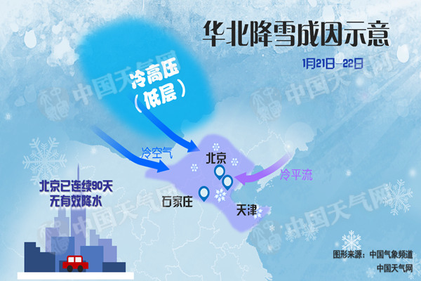
Cctv newsAccording to China Weather Network, since January 21st, a new cold air has hit strongly, and the northeast region is the first to be affected, with extremely cold weather of -40℃ locally. As the cold air moves southward, it is expected that many places in the central and eastern regions will spend the coldest week since this winter from today (22nd) to 26th, and the temperature in most areas will drop by 6 ~ 10℃. Due to the influence of cold air, the foggy and hazy weather in Henan and Jiangsu began to weaken and dissipate at night today. Around the 25th, the lowest temperature 0℃ line moved southward to the area from Zhejiang to Guangxi. In addition, from tomorrow (23rd), the central and eastern regions will have a large-scale rain and snow weather lasting for nearly a week, and parts of Jiangsu, Anhui, Zhejiang, Hubei and other places will be blighted again, so it is necessary to take precautions in advance.
This week, cold air swept through many places in the central and eastern regions, and it will be the coldest week in winter.
A new strong cold air first arrived in the northeast and the central and eastern parts of North China on the 20th, and the temperature dropped sharply in Inner Mongolia, Heilongjiang and Hebei. Monitoring shows that at 5 o’clock today, compared with 5 o’clock yesterday, the temperature dropped by 6 ~ 8℃ in eastern Qinghai, western Gansu, central and western Inner Mongolia and northern Heilongjiang, and the local temperature dropped by 10 ~ 12℃.
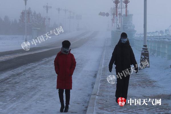
Yesterday, the lowest temperature in Mohe, Heilongjiang was -41.5℃, with ice fog and visibility less than 50 meters. (Li Zhe)
As the region with the most lasting influence of this round of cold air, the temperature in most parts of Northeast China will hit a new low. It is expected that the highest temperature in Harbin will drop below -20℃ from today, and it will continue to hit a new low for the next four days, with the lowest temperature below -30℃, and it may drop to -35℃ on the 24th, which is likely to break the extreme value of the lowest temperature in the same period in history (the lowest temperature in the same period in 1961 was -34.4℃). Looking back at the cold wave of the century in 2016, the lowest temperature in Harbin dropped to -31.4℃, and the degree of cold was even worse this time. In addition, the temperatures in Shenyang and Changchun will also hit new lows continuously. During the working day, the highest temperature in Changchun is around -20℃, and that in Shenyang is below -10℃.
As the cold air continues to move southward, it will sweep across the central and eastern regions from today to the 26th, and many areas will spend the coldest week since this winter. The Central Meteorological Observatory predicts that from 22nd to 26th, northerly winds of 4-6 grades will appear in most parts of central and eastern China from north to south, with gusts of 7-8 grades. The cumulative temperature drop is 6 ~ 10℃, and the local temperature can reach 10 ~ 14℃; The daily average temperature will change from the current high state to the low 2 ~ 5℃; During the period, the lowest temperature line of 0℃ will be pressed south to the northeast of Jiangnan to the northeast of Guangxi and the south of Guizhou, and the -10℃ line will be located in the eastern part of Huanghuai, the southern part of North China and the eastern part of Northwest China. From 27th to 30th, due to the influence of supplementary cold air, the temperature in the central and eastern regions will drop and remain low, and the lowest temperature line of 0℃ will continue to press southward to the northern part of Guangxi and the northern part of Guangdong to the northern part of Fujian.
Among the provincial-level cities, Wuhan and Nanjing are likely to fall to freezing point or below. Among them, the highest temperature in Nanjing is 12℃ today, but it will only be 0℃ on the 25th. The cumulative cooling is very obvious, and it really feels like a cold winter. With the rainy weather in Guiyang, it will drop from 17℃ on the 24th to 0℃ on the 26th. In just two days, the drop will exceed 15℃, and the change of temperature is very rapid. The public should pay attention to cold and warmth to avoid frostbite.
It is expected that the cold air intensity will be weaker in early February than in late January, and the temperature in the central and eastern regions will gradually rise to normal levels.
Yesterday, there was a heavy snowstorm in Beijing, Tianjin and other places from the first snow to Sunday in Jiangsu and Anhui.
Yesterday, the rain in the south gradually developed eastward, and the eastern part of southwest China, the south of the Yangtze River and the western part of South China were shrouded in rain, with moderate rain in some places in the lower reaches of the Yangtze River. In addition, last night, snow fell in Beijing, Tianjin and other places at the beginning of this winter, with light snow in parts of central and southern Inner Mongolia, northwestern Shanxi and central and northern Hebei, medium snow in central Hebei and central and southern Tianjin, and heavy snow (5 ~ 9.1 mm) in Baoding, Hebei and Tanggu, Jinghai and Dagang, Tianjin.
Today, there is still snow in parts of North China, while the rain in the south is temporarily suspended, but from tomorrow night, China will usher in a new round of large-scale precipitation weather, which will last for nearly a week.
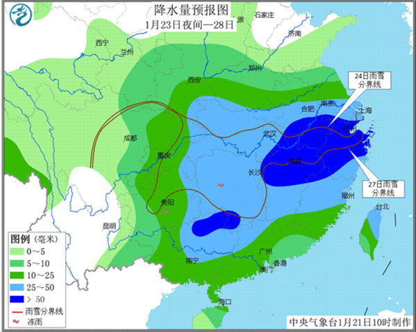
The Central Meteorological Observatory predicts that there will be moderate to heavy snow or sleet in eastern Gansu, Shaanxi, Shanxi, Henan, Hubei, Shandong, Anhui, Jiangsu, Hunan, northwestern Jiangxi and northern Zhejiang from the night of 23rd to 28th. Among them, some areas in southeastern Shaanxi, southern Henan, western and northern Hubei, Anhui, southern Jiangsu, northwestern Zhejiang and other places have blizzards, with local blizzards; The accumulated amount of rain and snow in the above areas is 10 ~ 30 mm, the local area is 40 ~ 60 mm, the newly added snow depth is 8 ~ 30 cm, and the local area can reach more than 40 cm; The strongest snowfall period is from the day of 24th to the night of 25th. There are moderate to heavy snow and local snowstorms in parts of eastern Qinghai, eastern and southern Xizang. In addition, there will be freezing rain in parts of Guizhou and Hunan.

Meteorologists reminded that Beijing-Tianjin-Hebei and other places have finally ushered in the long-awaited snowfall. While being happy, we also need to pay attention to the adverse effects of road icing on road traffic. We should pay attention to travel and beware of falling. In addition There will be a wide range of rain and snow weather that will last for a week from tomorrow. The public should pay attention to the approaching forecast and take preventive measures in advance.
Fog and haze weather in Henan, Jiangsu and other places continued to weaken and dissipate tonight.
The Central Meteorological Observatory predicts that there will be heavy fog or fog in southern Henan, Anhui, Jiangsu, central and eastern Hubei, northern Hunan, southern Sichuan Basin and other places from this morning to this morning. Among them, some areas in northern Anhui, southern Henan, central Hubei and northern Hunan have strong fog with visibility less than 200 meters, and local visibility is less than 50 meters. The Central Meteorological Observatory continued to issue a foggy orange warning at 06: 00 on January 22.
At the same time, today, the diffusion conditions of air pollution in southern Shanxi, central and southern Henan, southern Shandong, central and northern Anhui, central and northern Jiangsu, northern Hubei, Guanzhong, Shaanxi and other places are still poor, with moderate to severe haze weather. From tonight, affected by strong cold air, the persistent smog weather in the central and eastern regions gradually weakened and dissipated from north to south.